News & Community
Is Maryland Becoming the New Tornado Alley?
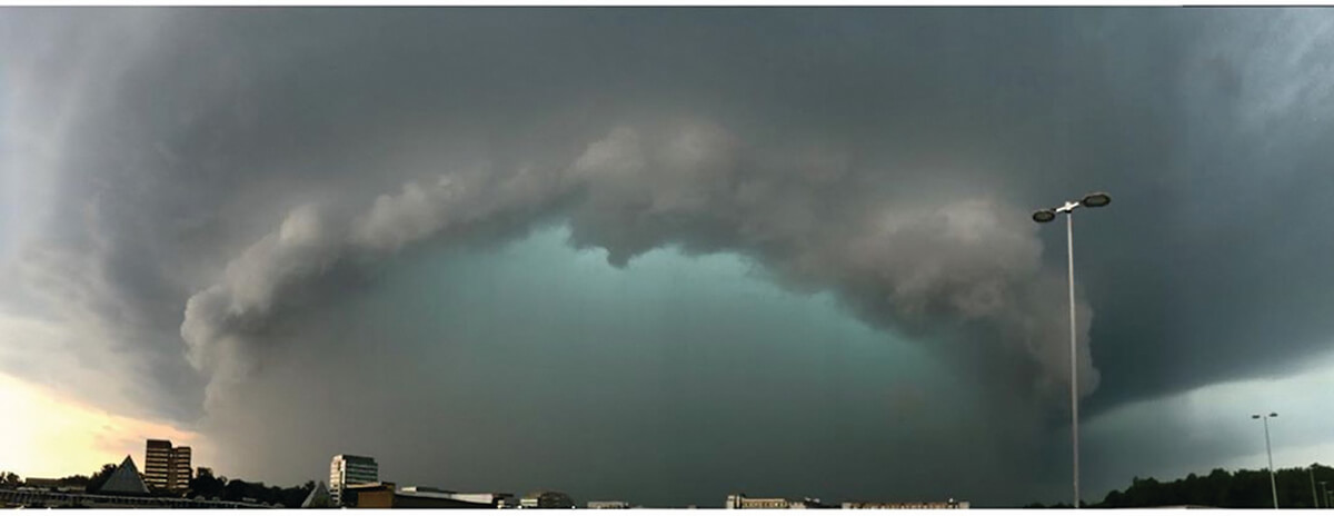
“It looks like the mothership approaching,” says Jeff Halverson, referring to the ominous green-hued storm that touched down in 2019 in Howard County.

“It looks like the mothership approaching,” says Jeff Halverson, referring to the ominous green-hued storm hovering over the Columbia Mall (pictured above), which brought on a tornado that touched down May 23, 2019, in Howard County.
“That’s the leading edge of a fast-moving shelf cloud, a linear formation that hangs very low, is turbulent and chaotic. The green color you see,” continues Halverson, a professor of Geography and Environmental Systems at UMBC, “it’s an optical effect from heavy rain and hail stones reflecting certain wavelengths of sunlight, and when you see you it, you know all hell is ready to break loose.”
The National Weather Service rated the twister that emerged from that storm an EF-1, second-lowest on the 0-to-5 scale for tornado intensity. But with winds raging past 100 miles per hour, it was powerful enough to snap numerous trees, including one in Columbia that split a home in half, and rip part of a roof off another building.
Amazingly, another tornado touched down a week later in Howard County, toppling trees and damaging buildings again. Six months prior, in November 2018, a tornado struck Southeast Baltimore, partially collapsing an Amazon distribution center and killing two workers.
So is Maryland suddenly becoming the new Tornado Alley? The better question might be, does anyone remember these back-to-back twisters in Howard County? Or, the 11 tornadoes that Hurricane Isaias spawned across Southern Maryland and the Eastern Shore last August?
Sure, many people will remember Hurricane Isabel in 2003—estimated damages came close to $1 billion in Maryland and Washington, D.C.—when images of Baltimoreans paddling around downtown made the news. But what about the rest of our extreme events?
“We do have kind of a shared amnesia,” Halverson says. “I think it’s a coping mechanism. If it hasn’t hurt our house, our family, our brain pushes it back in our memory and we think, ‘Oh that stuff doesn’t happen here.’”
For Halverson, understanding superstorms, tornadoes, hurricanes, and derechos—remember the one in 2012 that took just 12 hours to race from Illinois to Baltimore?—is his life’s work. Although a teaching professor, he has also been a “storm chaser.” Yes, like in the 1996 film Twister, starring Helen Hunt and Bill Paxton. In fact, there’s now an annual Mid-Atlantic Chaser Con, where he presented, virtually, last year. Except the 54-year-old Halverson began his post-doc career chasing hurricanes, not tornadoes, flying into monster storms off the Atlantic coast of Africa as a scientific researcher.
“When they’re that far over the ocean, you have to take the instruments to them to measure them,” Halverson says. “It is safer 40,000-feet up at the top of a hurricane, and you’re strapped in with a harness with a former astronaut flying the plane. The hard part is getting in and out through wall [clouds]. The calm in the center of the storm? That’s true.”
Today, it’s Halverson’s mission to get his students interested in the science behind such storms. As a member of The Washington Post’s Capital Weather Gang, he also reports on extreme events and educates the general public, an ever-more critical role as storms become stronger with climate change. His own interest in weather began “at age 4” at the knee of his grandfather, who raised him.
“He was an aviator, a former World War II pilot who was shot down in the Battle of Midway and survived on a raft after sharks had gotten to other crew members.
“So he knew all about weather and weather instruments, and he taught me about cumulonimbus storm clouds when I was a kid. I soaked it up. I even took fly lessons, too. I wanted to be like him.”